Do-It-Yourself Aerial Photography in Israel/Palestine
Hagit Keysar

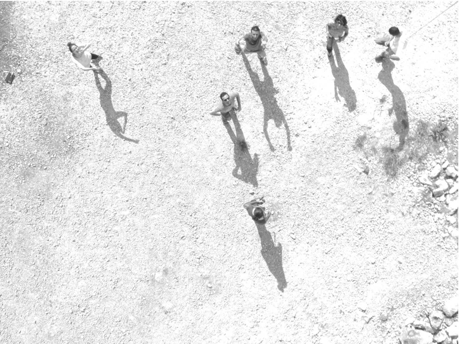
Kite mapping workshop, Silwan, East Jerusalem, July 2011.
In the early 2010’s I came across a Do-It-Yourself (DIY) aerial photography technique that triggered my imagination and captured my attention for the following years. The technique is a curious one, based on a very simple camera rig made out of a plastic soda bottle that is cut into half for nestling inside a simple digital camera pointed vertically to the ground. The whole thing is tethered to the string of a kite or a balloon and sent to hover in mid-air as the camera takes images continuously.
Since 2010, this curious instrument has enabled people around the world to produce beautiful and captivating images that brought forth environmental and spatial evidence and testimony.1
For me, it opened a door to the world of open source technologies and communities, and to the agency of mapping. Immediately and intuitively, it turned out to be a new path for my activist work within the ongoing conflict and colonization in Israel/Palestine. And soon after, it grew into a practice-based research project, opening a whole new angle to my visual work and research around the politics of photography and technological objects.2
I began creating aerial photography with inhabitants in Israel/Palestine, documenting, investigating and representing different issues and stories that concern people in the Jerusalem/al-Quds area and beyond. While it is possible to use commercial imagery from Google Earth or other providers, these technologies often have several significant limitations such as cost, copyright restrictions, low resolution and outdated imagery. Google and other US companies that produce satellite imagery reduce their commercial images to 2.5 m2 per pixel, as per international legal agreements between Israel and the US.3 The civil uses of commercial aerial and satellite imagery of Israel and the occupied Palestinian territories are thus very limited and expensive for human rights organizations to use, and virtually unattainable for local grassroots organizations.
Jeff Warren with children flying the kite during the workshop, Silwan
One of the first kite photography workshops in Jerusalem was conducted in July 2011 with a group of local Palestinian activists in the neighborhood of Silwan, in East Jerusalem. Silwan is located at the southern slopes of the Old City; it is one of the centers of resistance to Israeli occupation and colonization in Jerusalem. Its residents, like many Palestinians in East Jerusalem, live under heavy military and police presence and the constant pressures of displacement and eviction. Constant surveillance measures in East Jerusalem are aided by extensive use of aerial/satellite imagery, drones and regular use of surveillance balloons, infringing on the freedoms and privacy rights of urban dwellers.
For urban residents, in contrast, the view from above is highly inaccessible. Besides the costs and censorship of aerial and satellite imagery, the use of commercial drones is forbidden without special authorization in all of Jerusalem, and the Old City is surrounded by a No-Fly-Zone that stretches 3km in diameter and covers the whole area of Silwan and beyond.4 What kind of role might Do-It-Yourself balloon and kite photography practices play within such an intense environment of techno-political control? How might DIY technoscientific tools and techniques serve Palestinian residents in East Jerusalem in reclaiming rights and contesting the oppressive control over their living environment? The idea to independently create aerial photographs of the neighborhood was in line with the activists’ efforts to free themselves from dependency on UN agencies and local human rights organizations, which offer aerial maps and images which are not necessarily up-to-date and do not always fit the residents' particular needs.
The workshop took place over the course of two weeks. We worked with children aged 10-12. Together with the community activists we managed to create an aerial photograph that covered most of the area of the neighborhood, in large part thanks to the children’s ingenious kite-flying skills. Uploading the photos online to be stitched on Public Lab’s MapKnitter software meant that the up-to-date, high-resolution geographic information they produced would be accessible on the web. The activists we worked with did not want to open the data publicly due to the political sensitivity of the geography; therefore, we created a password so that only authorized persons could access the map.5
After the children stitched the map together, they annotated it with their own stories. Their discussions and annotations of the aerial view exposed a detailed composition of the ways in which surveillance measurements take shape in Silwan and within their everyday lives (see image of poster below). A recurring element in the children’s stories was the constant presence of military and police, and the constant feeling of being watched and observed. They immediately identified and marked their homes and points in their streets in which Israeli security forces, CCTV cameras, and armed private security guards (guarding Israeli settlements and settlers within the neighborhood) are present. The DIY view from above that they created opened up a way of seeing which exposed a surveillance machine that can only be fully seen and grasped by those who are being watched.

After the successful flight of the kite-tethered camera, we began stitching the photos together using MapKnitter.org, Public Lab’s open source software for making a photographic map of DIY aerial images. We later printed an initial stitch and began a process of annotation.
In contrast to the 2.5 m2 per pixel in most online sources, the resolution of the DIY aerial image was 3cm2 per pixel, therefore, it was quite immediately legible to the children and the activists—bypassing the need for expert analysis, or more correctly, clarifying the urgent need for a whole different kind of knowledge for interpreting the image. By flying the camera tethered to a kite, stitching an aerial image of a large area, and later interpreting and annotating it, one can say that the children became satellites for their own community.
The children took photos in the neighborhood of places that are important to them and wrote short texts. The next phase was to integrate all the materials collected into the DIY aerial image.
Doing DIY aerial photography in Israel/Palestine, and more broadly in areas of conflict and colonization, introduces extra complexities. A salient question that arises is the ambiguity of its possible legal consequences. Air regulations may be similar in Palestinian East Jerusalem and in West Jerusalem’s Jewish areas, but practically, taking aerial photographs in each area is a very different experience. The workshop in Silwan went on peacefully but we had to consider the fact that creating DIY aerial photography above the highly controlled and militarized area is an activity liable to raise authorities’ suspicion and intervention; while in the western city’s Jewish environment, this reaction was far less likely to happen. Despite this tension, whether in East or West Jerusalem, the ease and playfulness of sending a kite with a camera into the sky and then using the images to stitch together a geo-rectified aerial photo has allowed people to tell a completely different story about their urban environment. It hints at the possibility to negotiate and reconfigure “ownership” over the view from above; it is a reminder that the geography, space and its imagery should be made open to everyone so it can be equitably understood, visualized and interpreted by its inhabitants, whoever they are—Jews, Palestinians, citizens and non-citizens, experts and non-experts.
~
Participants in a kite-mapping workshop in Beit-Safafa, East Jerusalem. Image captured in flight, May 2013.
Click on the tiles to explore the map


- This technique was developed by Public Lab, a community supported NGO that develops do-it-yourself and open source tools and methods for citizen-driven environmental health and justice investigations. Visit PublicLab.org to learn more. The site has many research notes by people who have used the technique for various environmental and spatial investigations; for examples, see the Public Lab’s archive.
- For more about the research, click here. For more about the work conducted with DIY aerial photography in Israel/Palestine, click here.
- See more on this in “Whither high-resolution satellite imagery of Israel?” and Public Law (1996), Sec. 1064. Prohibition on collection and release of detailed satellite imagery relating to Israel.
- This No Fly Zone includes a geofence that bans drones from flying into it or taking off within its boundaries. For visual work on the topic, click here; in Hebrew at more length, click here.
- MapKnitter.org is a Public Lab open source software that allows DIY aerial photographers to stitch together several aerial images and create a photographic map of larger areas that embeds geographic information in its metadata.